Manaslu circuit Trekking
Manaslu Circuit trekking is one of the most spectacular trek in the Manaslu region of himalayan. It is well known as Japanese mountain. The first expedition was done by japanese every year from1952 until 1956.
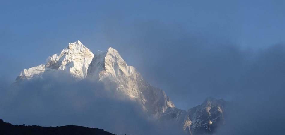
Manaslu is the eighth highest peak in the world at elevation of 8163 metres. Manaslu trek start from the historical place of gorkha. The path heads up the valley of Budi Gandaki river and Marshyangdi river. Biological diversity, cultural and historical heritage, ethnic group of people and their hospitality, mountain panorama make this trekking more exciting. The trail goes through Manaslu peak crossing Larkya pass at 5100 metres and then join the river valley of the Dudh Khola and
finally emerges onto the Marshyangdi river valley and meet the main way of Annapurna Circuit. This expedition end in two ways. First way is that you can continue by downward trail along the Marshyangdi river valley through rhododendron and oak forests. And next trail is to conclude this trip Bhubule and drive to kathmandu. The suitable time for this trip is from march to may in spring season and September to November in autumn season.
Mount Manaslu is the 8th highest mountain in the world. Its altitude is about 8163sq km. Manaslu means’The spirit mountain . Manaslu trekking is one of the popular trekking trail lies in western part of Nepal. Manaslu region is known as manager base camp trekking for stunning Himalayan secenary of Mt. Manaslu region and Annapurna trekking region. Trekking in manaslu region provides spectacular beauty along with the boarder of Nepal and Tibet. Trekking in manaslu is life time journey for adventure travellers. Normally, March, April, may, September, October, and November are best month for trekking in manaslu region. Manaslu trekking offer pristine mountain, views, beautiful landscape, lush valley, and combination of cultural heritage. Gorkha district after 6-7hours drive from Kathmandu. Manaslu large pass join with Annapurna circuit trekking trail. Manaslu trekking includes tea house ,camping, and tented trekking.
Apart from that Trekking in Nepal Info arrange manaslu trekking as per trekkers wish and holiday schedule with life time journey in Nepal.
Trekking in Nepal Info mentioned Two option:
Option I : Manaslu circuit Trekking
Optiona II: Manaslu base camp Annapurna time-honored circuit trekking.
Manaslu circuit trekking trail strongly influenced by Tibetan inhabitants. Manaslu circuit trekking enter to the Annapurna region at Dharapani so that travellers may extend their journey to Annapurna circuit trekking. Annapurna circuit trekking or Annapurna thorangla pass trekking need minimum two people participation to make manaslu larke La pass trekking as per Nepal government rules and regulations through Nepal government registered trekking agency. Since, manaslu base camp trekking trail has been opened.
Trekking in Nepal Info operate numerous trekking group in relevant areas with life time Nepal Himalaya Experience.
Since, Manaslu base camp trail had been opened.
Trekking in Nepal Info arrange numerous trekking groups in Manaslu region.
Our guide led through the beautiful valley of Arughat satikhola, jagat, Dhilim, Dang, Namrung, Samagaun, Samdo and finally across the lake pass 5153m and enter the Annapurna circuit trekking trail at Dharapani.
Itinerary
- Day 1: International Arrival in Kathmandu [1,300m/4,264 ft] - Transfer to Hotel
- Upon our arrival at Tribhuvan International Airport (TIA) in Kathmandu, we will be warmly greeted by a representative from TINI. After completion of our custom formalities (Visa, etc), we pick up our luggage and look for our representative with TINI display board at the arrival gate. We will be then escorted to Hotel in Kathmandu. After check in, we can either take a rest or hang around in the city or visit TINI office site. It all depends upon our interests and condition. At the evening upon our reception, TINI will organize a Welcome Dinner at an excellent traditional Nepalese restaurant where we enjoy a Nepalese cultural program as well as a fine meal. Included meal: Dinner (D)
Note: B refers to Breakfast, L refers to Lunch and D refers to Dinner
- Day 2: Kathmandu: Sightseeing and Trek Preparation
- Today after breakfast we start a guided tour to several of the most historical and spiritual attractions in Kathmandu. Some of these landmarks are considered World Heritage Sites; including the historic Durbar Square, the sacred Hindu temple of Pashupati Nath, the famous 'Monkey Temple' (Swayambhunath) and Buddhists shrine (BouddhaNath) which is one of the large Stupas in the world. At the noon, there will be a pre-trip discussion where we can meet our trek leader and other team members. TINI briefs us regarding our trek as well as provides us opportunity to ask any questions we may have regarding our upcoming adventure. Overnight at Kathmandu. Included meal: Breakfast (B)
- Day 3: Drive Kathmandu to Arughat [600m/1968 ft]: 7 - 8 hrs drive
- At dawn, we set off early today for Arughat. We drive through countryside of Nepal enjoying the countryside and mountain sceneries. First part of drive is easier until Dhading Besi, the headquarter of Dhading District. Another part of drive starts from Dhading Besi to Arughat through direct road and we reach Arughat after around 7-8 hours' drive. Arughat, our trek starts point is a major town in the region and is divided in two parts with the Budi Gandaki River flowing between them. Overnight at Arughat. (B,L,D)
- Day 4: Arughat - Soti Khola [710m/2328 ft]: 5 - 6 hrs
- Upon crossing the bridge over Budhi Gandaki, we begin our trek from the western part of Arughat. After completing with the ACAP procedure, we follow the stone-paved street north through the bazaar. We further pass through the hydro-electric power project, fields of rice and millet to Maltar, and through forests Sante Bazzar. The trail to Budhi Gandaki valley now becomes steeper and more difficult as we cross the Arkhet Khola on a suspension bridge, passing the shops of Arkhet. While descending we encounter with a cascading waterfall making a long steep slog up a ridge to Kyorpani. Then from here the trail descends to Soti Khola. Overnight stay at the campsite at Soti Khola. Overnight at Soti Khola. (B,L,D)
- Day 5: Soti Khola - Maccha Khola [900m/2952 ft]: 6 - 7 hrs
- At the crossing of the bridge, we trek through the beautiful Sal forests, then climb onto a bridge above huge rapids on the Budhi Gandaki. We then reach to Khursane. The rocky trail then weaves its way up and down, past two tropical waterfalls on a steep, rocky trail clinging to the side of a cliff. It eventually makes its way down and past a few rice terraces, then up and around to the Gurung village of Labubesi. We further climb behind a rocky outcrop, where the valley opens and the Budhi Gandaki meanders among wide gravel bars. Dropping to the sandy river bed, we walk along rounded stones before climbing over a side ridge. We head down again to the river and traverse to Machha Khola village. Overnight at Machha Khola. (B,L,D)
- Day 6: Maccha Khola -Jagat [1410m/ 4625 ft]: 7 - 8 hrs
- The narrow trail makes some minor ups and downs and eventually crosses the Tharo Khola, flowing in a rocky ravine, then reaches Khorlabesi. After a few more walk ups and downs, there is a small trailside hot spring, from where we reach to Tatopani. From the Hot Spring we climb over another ridge, then cross the Budhi Gandaki on a suspension bridge. At this juncture, we climb on a wide, well-crafted staircase, then across a landslide and over a ridge to Dobhan. Upon crossing a suspension bridge over the Yaru Khola, we climb the stone stairs and then drop to the river and again climb more stone stairs to Tharo Bharyang. Crossing to the west bank of the Budhi Gandaki, we climb over a ridge, trek along the river and then climb towards the village of Jagat. Overnight at Jagat. (B,L,D)
- Day 7: Jagat - Deng [1,804m/5917 ft]: 7 - 8 hrs
- Today at the beginning we climb over a rocky ridge to Seller, and then descend to Setibas. The valley widens a bit as the trail continues up to Ghatta Khola. We further continue walking upstream to a long suspension bridge. While climb up to Philim we will be at a large gurung village. The trail turns north just above the lowest house in the village and stays fairly in level as it traverses millet fields to Ekle Bhatti. Beyond Ekle Bhatti the route enters a steep, uninhabited gorge. At this moment, we descend to the grassy land slopes, cross the Budhi Gandaki, then trek along the west bank for a while, then cross to the east bank and then back again. As we keep walking the valley widens through bamboo forests to the Deng Khola. Upon crossing the khola, we reach at the tiny village of Deng. Overnight at Deng. (B,L,D)
- Day 8: Deng - Namrung [2630m/8626ft]: 6 - 7 hrs
- After a brief walk beyond Deng, we cross the Budhi Gandaki on to the north bank and then climb to Rana at 1910m. From the bridge we climb a bit to join a trail from Bhi, then head west up the Budhi Gandaki valley. Making ups and downs in forests, we pass mani walls and then turn to a corner that contours to Ghap. Eventhough there is another route; we take route through Prok village. Prok village has a view point from where we see beautiful view of Siringi Himal. We further cross Budi Gandai several times today and come across several gompas en route. The trail follows the river upstream through dense forest. After crossing the river at an impressive spot where it thunders down a narrow gorge, the forest becomes less dense and the trail is fine again. The pleasant walk continues and after a last steep climb we reach Namrung. Overnight at Namrung. (B,L,D)
- Day 9: Namrung - Lho [3180m/10,430 ft]: 4 - 5 hrs
- Namrung villages is good viewpoint for Siring Himal and Ganesh Himal. There are also a MCAP office, health post, police station in Namrung. To the south rises, we will have the view of Himal Chuli, a huge peak. Climbing steadily in the shade of a forest takes us to Lihi, a fine village with many shortens and many barley terraces. We still have quite bit of trail to reach Lho. Ganesh Himal Rises high into the sky when we turn around. The trail drops and crosses the side valley of Simnang Himal. A chorten with detailed paintings announces Sho, another nice village with fine views up the open valley. We cross a stream short after leaving Sho and one final steep climb takes us to village with superb view of Mt. Manaslu. It is Lho Village where we explore the famous Ribung Gompa. Overnight at Lho. (B,L,D)
- Day 10: Lho - Samagaon [3530m/11,578 ft]: 4 - 5 hrs
- The Budi Gandaki is far down but we follow a small tributary instead. Walking in the shady fir forest is very enjoyable. Upon a short climb to a plateau we will be at Shyala village. Our arrival at the village will be surrunded by huge mountains and those are Himal Chuli and Peak 29 (Ngadi Chuli) to the left, Manaslu and large glaciers straight ahead, other snow summits to the right, at the far end stands Ganesh Himal. From a large chorten we look down into a little dip where two rows of houses form the main part of Sama. At the far end of the village, overlooking the valley stands the well-known monastery of Sama. Overnight at Samagaon. (B,L,D)
- Day 11: Samagaon - Pungyen gompa - Samagaon: 6 - 7 hrs exploration
- We spend the day at Samagaon both for rest and acclimatization. We pay our attention to ponder at the thousands of mani stones with Buddhist texts and pictures. At this juncture we meet the village women in Samagaon who wear a nice silver spoon as jewelry. On a little hill near Samagaon is an old Gompa. We take a side trip to Pungyen Gompa, a monastery with great views of the glacier. It is named after Manaslu; Pungyen means bracelet, a good description of the two peaks. It was destroyed a year after the first unsuccessful Japanese attempt to climb Manaslu. The locals believed that the climb angered the gods, and when the Japanese came back a year they met so much resistance that they had to give up their attempt. They finally submitted the mountain in 1959. Overnight at Samagaon. (B,L,D)
- Day 12: Sama - Samdo [3860m/12,660 ft]: 4 - 5 hrs
- Today, while descending to the Budhi Gandaki River, that has turned north, we follow it to a bridge over a side stream. The trail to the left leads to the Manaslu Base camp. The Larkya la Trail passes several mani walls as the valley begins to widen. It is an easy trail on a shelf above the river passing the juniper and birch forests of Kermo Kharka. We drop off the shelf, cross the Budhi Gandaki on a wooden bridge and climb steeply onto a promontory between two forks of the river. From a stone arch we can view a large white kani. Finally passing through the kani we find Samdo. Overnight at Samdo. (B,L,D)
- Day 13: Samdo - Dharamsala/Larkya B. C. [4460m/14, 628 ft]: 4 - 5 hrs
- Even today, we continue our walk down the edge, cross the wooden bridge over Budi Gandaki and begin walking upward. Upon crossing two streams and witnessing the Larkya Glacier we go around the valley of the Salka Khola and climb up again and come to the stone guest house (4450 m) which is not a lodge but a kind of shelter called Dharmshala, also known as Larkya Phedi. We camp here today and have a rest to prepare for next day's journey. The short walk today also leaves plenty of time for acclimatization and relaxing in the afternoon. Overnight at Dharmashala. (B,L,D)
- Day 14: Dharamsala - Larkya la [5160m/16, 924 ft] - Bimthang [3720m/12, 201 ft]: 8 - 9 hrs
- After a short climb, we reach the ablation valley on the North side of the Larkya Glaciers. Upon this moment we will have the views of Cho Danda and then of Larkya Peak. Finally, we walk across the moraines of the glacier, making a gradual ascent which becomes steeper only in the last section to the pass. From the pass, there are outstanding views of Himlung Himal, Cheo Himal, Kangguru and the huge Annapurna II. At here, we savor the spectacular views from the top of the pass. It is a longer day then usual to Bimtang. But to walk into these low pastures with the evening mist coming in and Manaslu will be an experience not to be missed. Overnight at Bimthang. (B,L,D)
- Day 15: Bimthang - Tilije [2300m/7544ft]: 4 - 5 hrs
- From a ridge at Bimthang, we will have very beautiful views of Mt. Manaslu, Lamjung Himal, Him lung Himal, Cheo Himal. We further walk down and cross the high pasture (Sangure Kharka). Beyond a bridge over Dudh Khola, we descend into a rhododendron forest and follow a trail through a narrow valley until we reach the highest cultivated land in this valley at Karche, 2785 meters. From here we cross a slide, then go across fields before making a steep climb over a ridge. The trail comes off the ridge in a big, sweeping arc to the river bank at 2580m. A short distance beyond is the village of Gho. Due to yesterday's tiredness we might take overnight rest at Gho but better lodges are available at Tilije, so TINI recommends staying at Tilije. Overnight at Tilije Village. (B,L,D)
- Day 16: Tilije - Tal [1700m/5576 ft]: 5 - 6 hrs
- Today, we climb over a small ridge to the stone - paved village and wind among the closely spaced houses of this large village. Upon leaving the village, we cross the Dudh Khola and trek along the river embankment. Crossing at a wooden bridge back to the northern side of the Dudh Khola and climbing up through a shorten-shaped arch and passing a mani wall, we will be at Thonje village. At the village of Thonje, we go through a police checkpoint and then continue to Dharapani. We have entered the Annapurna circuit section from Dharapani. Further down we come across Karte village and after quite a bit of walk we cross a bridge over Marshyangdi Khola. Further, we come across some Mani Walls before reaching village of Tal where there is ACAP office. Tal Village is situated at the foot of a large waterfall. Overnight at Tal. (B,L,D)
- Day 17: Tal - Syange [1080m/3542 ft]: 6 - 7 hrs
- Today, our journey from Tal to Syange begins. At the beginning the trail continues on to Chyamje Recrossing the Marshyangdi Khola once again. The Marsyandi valley opens with its banks terrace fields and villages clung very high to the hillsides. The trail then descends through forests of rhododendron and pine to Syange. Overnight at Syange. (B,L,D)
- Day 18: Syange - Besi Sahar (800m/2625 ft) - Kathmandu: 4 hrs
- An 8-9 hours picturesque drive on the way back to Kathmandu along the banks of the Marsyangdi and Trishuli rivers offers splendid views of green hills, mountains, farming terraces and villages on both sides of road. In Kathmandu, we will be escorted to our hotel. The day in Kathmandu either spend on leisure or perhaps we catch up some last minute shopping or explore any sights we missed during our first day in Kathmandu. In the evening, we will be at a host dinner to celebrate our successful completion of Around Manaslu Trek. Overnight in Kathmandu. (B,L,D)
- Day 19: Farewell Friend
- Our journey in Nepal comes to an end today! Trekking in Nepal info P. Ltd. escorts us to the airport for our flight time. Approximately 3 hours before our scheduled flight, a representative from TINI will escort us to the airport and bid farewell greetings. (B)
Note: We can aslo customize above Itinerary as per requirements
Quick Inquiry Form